


Remote Sensing
In many cases, studying certain phenomena demands the use of special airborne sensors, complementing aerial photography and digital cartography. This allows for the recording of phenomena and elements not visible by human eye.
Using the appropriate airborne sensors, special films and multispectral scanners we are able to record various environmental phenomena, identify and map heat dissipation of urban areas, locate diseases of forest trees and also identify pollution in water bodies.
Geomatics takes advantage of recent developments in airborne remote sensing offering a wide range of services that allows for clients to get immediate and reliable information in which enables them to operate in an environmental friendly manner.
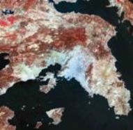
At the same time, using various satellite images, the company carries out a number of surveys and mapping projects related to:
Land use mapping.
-
Large scale land cover change detection.
-
Thematic mapping.
-
Agricultural crop identification.
Having strong background in GIS systems and software, the company offers products and services regarding:
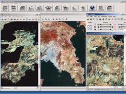
- Geometric and radiometric correction of satellite imagery (Landsat, Spot, Ikonos, QuickBird, IRS)
- Satellite imagery mosaicking and production of satellite orthophotomaps.
- DEM production using satellite imagery stereo pairs.
- Processing, analysis and classification of satellite imagery