


GIS
Geographic Information Systems, state-of-the-art technology in scientific and geoinformatics applications, has always been a serious challenge for Geomatics, which is a leading company in this field in Greece with multifaceted activity.
The applications, products and services offered by Geomatics in the area of GIS include:
- Custom applications development and GIS prototypes, systems programming and applications documentation.
- Comprehensive solutions in terms of design, installation and operation of Geographic Information Systems.
- Commercial applications development in the areas of market research, product distribution and telematics (Business GIS).
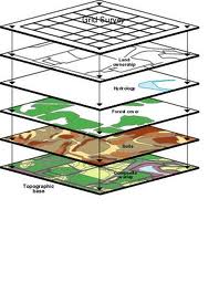
- Design, organization and development of geographical databases.
- Geocoding applications and routing optimization
- Automated Mapping, Facilities Management - AM/FM applications and urban management systems.
- Feasibility studies for the introduction of Geographic Information Systems in public organizations and local authorities.
- Consulting services, technical support and user's training in the use of GIS.
In today's GIS and telematics market there is a growing demand for quality data in a wide spectrum of applications either at country or at city level.
In Geomatics our philosophy in the field of digital data production is focused on:
- Quality
- Updates
- Accuracy
- Compatibility either between the various layers of information or between data of different resolution.
We produce data from scratch using our strong mapping facilities as well as the fully organized mechanism of collecting attributes and thematic information from several sources and the field. Besides that, a lot of data are produced in the framework of several projects, which are incorporated in our data sets constantly enriching the information available in our library.
Among the digital data and the services we offer, are included the following :
- High-resolution digital cartographic data production at city level.
- Digital cartographic backdrops and geographic databases at country level.
- Geographic database development with both spatial and attribute data.
- Thematic maps with statistical data.
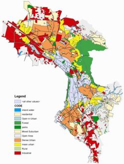
- Land use maps.
- Analog map digitization services, raster to vector conversion, building of data bases within GIS environment.
- Full digital cartographic data library at country level as well as urban centers with various attribute data.