


Geodatabases
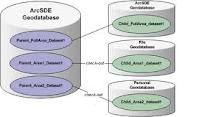
Geographical databases are created by linking digital maps to alphanumeric databases. The digital map is bi-directionally linked to a database, allowing the user to pose questions of either spatial (through the map) or thematic nature (through the data base), all inside the G.I.S. environment.
The geographical databases always constitute the heart of a G.I.S. and therefore represent its most powerful subsystem, given that every system's power depends on the volume and quality of the information it contains.
In GEOMATICS we develop geographical databases either in the framework of company projects, aiming at digital data production and distribution for various purposes, or in the framework of contracts, according to our clients' specifications.
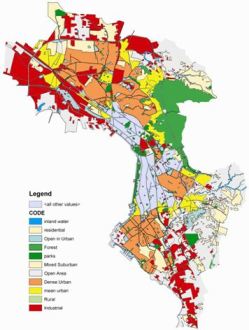
The digital data developed by GEOMATICS, such as urban areas digital maps combined with thematic information, are part of a big group of "ready to use" geographical databases owned by the company.
Additionally we can also create geographical databases "to order", according to our clients' specifications.
We use digitial maps of high resolution and accuracy, we collect all specialized information required by the client or incorporate data he provides us with, we proceed to data structuring and linking and we perform topological checks in order to provide our clients with reliable and highly accurate end products that can be incorporated and immediately used within their own G.I.S.
Contact us if you want to know more about our geographical databases or if you are interested in developing a database of specific content.