


3D Laser Scanning-Precision Surveys
Geomatics, following the developments in the field of precise surveys, has invested in equipment and software applications which allow us to conduct any kind of precision measurements and 3D modelling.
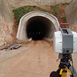
Measurements with terrestial laser scanners allow us to obtain a high density point cloud while though the proper processing we have the possibility to create 3D models of any object, industrial installation or archaiological monument and further to that to produce layouts, 2D or 3D views and sections at any level.
Besides that for documentation of monuments, building complexes or archaiological sites we use calibrated digital cameras for terrestial photography as well as special terretsila photogrammetry software tools allowing production of accurate large scale drawings and high resolution orthorectified images.
Equipment:
LEICA Scan Station II