


Tourist Maps
Taking advantage of GEOMATICS' rich archive of mapping data as well as the great volume of high quality descriptive information, we have developed quality tourist maps of high grade of accuracy, completeness and updating, especially flexible to use since all geoinformation is structured in different layers, in GIS environment. Such a data structure allows the user to choose the kind of information he desires, add his own information, change the map's scale, create 3D models e.t.c.
The maps cover urban areas as well as the entire country, and contain a variety of information which are available according to the desired printing scale.
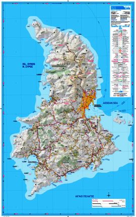
Maps at City Level - CitiesTOUR
City scale maps cover all prefecture capitals, s well as a great number of smaller towns all around the country. They are available either on a GIS friendly format, Adobe Illustrator, Postscript or other DTP friendly formats.
The city scale maps contain the following layers of information:
- Building Blocks
- Street names
- Characteristic buildings
- Points of interest
- Archeological sites
- Neighborhoods
The maps can be combined with color orthophoto maps of various resolution levels. It is also possible to add chosen information.
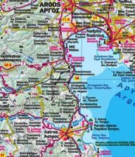
Maps at Country Level - HellasTOUR
Tourist maps are aimed at a large category of private and public sector users, such as publishing companies, tourist editions' organizations, prefectures, municipalities, cultural organizations, chambers e.t.c
Whether you are interested in a map covering an entire prefecture or the geographical area of a certain municipality, or even a tourist complex, GEOMATICS is able to provide all the mapping data you need in order compile a credible, updated and accurate base map.
Taking advantage of the power of GIS tools, we are able to produce a result containing and emphasizing on the particular mapping information which serves its purpose, such as the road network, routes of special interest, archeological sites, 3D models.
As for their contents, national scale maps are available on any of the following layers of information, weather separately in GIS environment, or in any other DTP friendly format.
Content:
- Road network classified in several categories
- Contour lines
- Color-graded altitudes
- 3D hill shading
- Cities - towns
- Toponyms
- Rivers - streams - lakes
- Points of interest
- Archeological sites
- Swimming beaches
- Monasteries
- Routes of special natural beauty
- Distances in Km