


Aerial Photography Processing
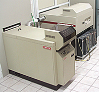
Geomatics owns state-of-the-art aerial photo processing laboratories, equipped with the latest developing and printing equipment, allowing for fully automated processing under controlled conditions.
Following internationally used practices and manufacturer's instructions regarding aerial film processing (fully controlled conditions and use of sensitometry and densitometry techniques), we produce superior quality aerial photos of high resolution and accuracy.
- Development and processing of color aerial films (Kodakcolor - Agfacolor) - C-41 process
- Use of dodging printers for the production of high quality aerial photos and diapositives.
- Development and processing of B/W films, printing of B/W aerial photos and diapositives - Use of automated developing processes.
- Printing of color aerial photos and diapositives (RA-4 process).
- Enlargements of color and B/W aerial photos
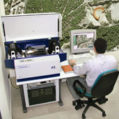
For the conversion of analog images to digital, Geomatics uses high resolution Z/I Imaging and Leica photogrammetric scanners. Z/I Imaging Photoscan 2002 photogrammetric scanner delivers superior quality digital images at resolutions up to 7 μm and a geometric accuracy better than 2 μm. Equipped with an automatic film roll-feed and winding system as well as AutoScan S/W it is able to produce large volumes of high resolution and accuracy scans at various compressed and uncompressed formats, applying advanced dodging and histogram correction techniques.
Using digital printing techniques such as Lambda technology, we deliver aerial photography prints and superior quality enlargements covering the greatest part of the country.